
Merchandise Dreams
The term "exurb" and its derivatives (exurbia, exurban, and exurbanites) are post-war American neologisms, introduced over half a century ago. While it's unclear if he coined the terms, writer A.C. Spectorsky is universally credited with introducing them into the lexicon via his 1955 satirical social history, The Exurbanites. This book offered the first detailed look at exurbia, then a nascent form of rural gentrification that leapfrogged established suburbs into the far-removed terra incognita surrounding New York City.
The meaning of the term has since shifted and expanded. Today, exurbia refers not only to rural gentrification but more generally to low-density settlements where a significant portion of the population is economically linked to a nearby metropolitan area. Exurbs are spatially separate from the contiguous metropolitan area, existing primarily as decentralized clusters surrounded by agricultural land. Situated at the intersection between the fringes of a large metropolitan area and the rural hinterlands beyond, the contrast between urban and rural is a defining feature of exurbia. It's this blend of rural setting and urban connection that distinguishes exurbs from traditional rural areas.
Laura Taylor, a scholar on exurbia, highlights an important distinction between exurbia as a "zone" and exurbia as a "place," urging us to consider both the land itself and the superimposed political and psychological constructs of society. This duality is coded within the term "exurb." The prefix "ex" carries two meanings: "extra-urban," signifying a location far from the city, and "ex-urban," suggesting a former connection to the city, like an ex-wife or expatriate. The former is geographic, referencing physical distance; the latter is cultural, relating to population migration.


Exurbia as Zone
Defining exurbia without quantitative analysis is fuzzy, and even the relevant quantitative frameworks have limitations. Three distinct concepts for defining these zones—"administrative," "land-use," and "economic"—have been proposed by John Cromartie and Shawn Bucholtz in a study for the United States Department of Agriculture's Economic Research Service (USDA/ERS).
The "administrative concept" defines urban areas along municipal, county, or other jurisdictional boundaries. This is the simplest way to distinguish between urban, suburban, exurban, and rural, but it's also the most problematic. Lacking numerical constraints, it often leads to subjective confusion. Densely populated municipalities, well above the U.S. Census Bureau's definition of urban density, are often colloquially called suburban. Similarly, a tract development in an unincorporated area, built to exurban density, might be considered suburban by its residents. This inconsistency in terminology is confusing when trying to differentiate development types.
The "land-use concept," as termed by Cromartie and Bucholtz, focuses primarily on settlement density. Geographer David Theobald offers a counter-argument, stating that settlement density doesn't account for second homes or vacation homes, common in exurban areas, and thus isn't a perfect metric for understanding landscape changes. He advocates for housing density (units per acre) as a more accurate portrayal of development patterns.


The U.S. Census Bureau defines an urbanized area as having 1,000 units per square mile (over 1.6 housing units per acre). This definition, while widely accepted among urban planners, includes places many would consider "suburban." A place with a population over 50,000, comprised entirely of single-family houses on half-acre lots, would meet this definition. This is comparable to, or even less dense than, many small towns. For example, lot sizes in the central area of Elburn, a typical Chicago exurb, are generally a quarter acre. This highlights a key problem: density, in isolation, doesn't always capture the context of a place.
Beyond the Census threshold, there are varying definitions of suburban, exurban, and rural densities. Theobald defines urban density as more than one housing unit per acre, slightly denser than the Census. However, his definitions of suburban (1 unit per 1-10 acres) and exurban (1 unit per 10-40 acres) are less dense than those of the Exurban Change Program at Ohio State University (ECP), which uses the Census definition for urban and suburban. The ECP proposes a denser exurbia (1 unit per 1.6-16.5 acres) and a denser definition of rural areas (less than 1 unit per 16.5 acres).
The "economic concept" relies on fine-grained, census-tract-level commuting data. The primary metric is the Rural-Urban Commuting Area Codes (RUCA) system, developed by the USDA/ERS. This system uses ten primary and thirty subordinate codes to describe population density and commuting patterns. It classifies areas as metropolitan, micropolitan, or small town, identifying core areas and surrounding settlements. This "urban cluster" concept better reflects the mobility afforded by the automobile.
RUCA codes also help identify areas where settlement classifications overlap. However, as a USDA product, the system is designed to assess rural places, not necessarily overlap areas like exurbia. RUCA codes are less useful for sub-classifications within metropolitan areas. Exurbia is largely included in RUCA classifications 1 and 2 ("metropolitan area core" and "metropolitan area high commuting"). This limits the granularity within metropolitan regions like Chicago. While helpful, these zone classifications aren't always the best way to pinpoint exurbia.


Exurbia as Place
In the Chicago metropolitan region, exurbs begin west of satellite cities like Aurora and Elgin, southwest of Joliet, and northwest of Fox Lake, where contiguous development starts to break up. These satellite cities were once commuter rail terminals. As development and employment have decentralized, so has the commutershed, evidenced by the westward extension of rail lines. Satellite cities became the edge of the metropolitan region as land along railroads, and later freeways, developed, creating a contiguous swath of development.
Places like Yorkville, Huntley, or Elburn, located ten miles west of the Fox River, were once small agricultural towns. They've seen increasing population density at their cores, while suburban-form, low-density developments have sprung up in surrounding areas. However, the characteristic low-density development of exurbia (averaging at most one housing unit per acre) primarily occurs in unincorporated areas, as indicated by the faster growth rates in townships compared to many municipalities.
The shift from agricultural to residential and commercial land use signals socio-economic change. Housing values, median incomes, and commute times increase as professional and service workers move into new developments. This creates a contrast between old and new, with tract homes abutting century-old farmhouses, and long-time residents finding themselves in the minority.


In his 1902 book Anticipations, H.G. Wells accurately predicted a century of urban transformation, emphasizing the importance of transportation and communication. He noted that "the determining factor in the appearance of great cities...has been the meeting of two or more transit lines...and easy communication." While writing about England, his observations apply to America. In Wells' time, transportation and communication were more fixed. Automobiles were rare, highways unheard of, and railroads operated on fixed routes and schedules.
Communication was similarly constrained. Telephones were uncommon, relying on infrastructure yet to be built. As telephones became ubiquitous, physical distances became less of a barrier. This pattern of decentralization has progressed exponentially. Transportation infrastructure expanded the possibilities of distance, while the Internet has contracted space through easier information exchange.
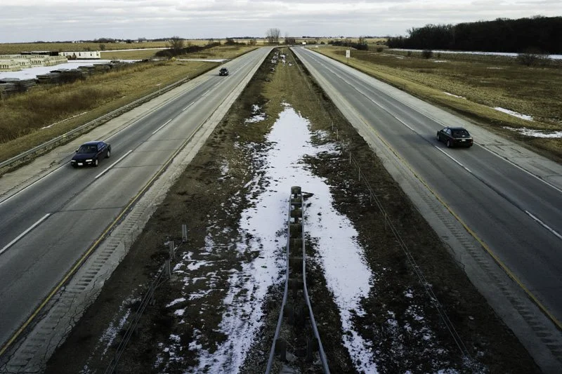
Wells suggested a one-hour commuting limit, "from sleeping place to council chamber." While not statistically verifiable, it raises a crucial question: are people willing to travel a certain amount of time, regardless of the mode? As employment centers push outward, so does the commuting radius. Increasing commute times are telling. The mean commuting time in Elburn rose from 25 to 30 minutes between 1990 and 2000, from 34 to 38 in Campton Township, and from 30 to 34 in Blackberry Township. Thirty to forty minutes of driving roughly equates to 20-30 miles. Given that a significant portion of the workforce in these areas is employed in professional and office occupations, we can infer that many commuters drive eastbound to work in offices west of I-355.


With the influx of professional and managerial workers, per capita and mean household incomes in Elburn nearly doubled between 1990 and 2000. The per capita income places the average resident squarely in the "middle class." Higher incomes allow for larger properties and increased privacy, suggesting that the wealthiest residents often live in unincorporated areas.
Exurbs represent a tenuous compromise between urban and anti-urban ideologies. Their urban characteristics are evident in tract housing, big-box retail, and a commuting population, all linking them to larger economic processes. Paradoxically, they are a culmination of the anti-urban American agrarian ideology, rooted in the pre-industrial past and exemplified by Thomas Jefferson. A.C. Nelson calls this the "Jeffersonian rural ethic." Jefferson, in Notes on the State of Virginia, advocated for an economy based on individual agricultural production. Today, more people are approaching the ideal of the independent gentleman farmer living in semi-isolation on a country estate.
Visually, it's difficult to definitively classify exurbs as more city than country. The forest preserves and cornfields are misleading. Exurbia has urban characteristics and is tied to the global economy, yet it appears as seemingly endless farmland dotted with urbanized clusters. These are not destinations, but rather, the spaces in between.


Architecture in the Exurbs
Contemporary exurban tract housing is derivative of existing building forms. Exurban areas in Chicagoland developed in four phases, loosely corresponding to economic booms and the expansion of transportation networks. These areas can be broadly divided into "town” — the old commercial center and surrounding older houses, and "country" — fields punctuated by homesteads and other agrarian architecture.
The first phase, around the turn of the 19th century, saw simplified Victorian-era frame houses in both town and country. The second phase, post-World War II through the 1950s, introduced single-story Ranch-style houses, a radical departure from their predecessors. These often included attached garages but were otherwise modest. The 1950s also saw the emergence of ribbon development: non-farmhouses built linearly along country roads.
During these first two phases, commercial areas were typically confined to a single main street. The third phase, starting in the mid-1970s, saw small strip malls built further from the town center. Few houses were built in town centers; instead, development occurred on reclaimed farmland or previously unused land in unincorporated areas. Housing developments began to use larger land areas at lower densities, breaking from pre-existing road patterns.
The fourth phase, beginning in the mid-1990s and arguably ending with the late-2000s economic downturn, saw scaled-up commercial development (larger lots and buildings). New housing was similarly scaled up, marking the boom period that transformed these areas into exurbs. This phase includes a diverse mix of styles and a greater difference in densities between developments.


Housing in modest socio-economic exurban subdivisions often derives from simple structures. The latest phase includes the "McMansion," described by historian Robert Bruegmann as "large exurban houses...with their quarter-mile driveways, acres of carefully tended lawn, and an assortment of late-model cars and boats sitting in front of vast garages." McMansions are status symbols, representing the extreme of a continuum where wealth is signified by lot size and square footage.
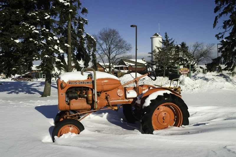
If houses signify wealth, the non-functional tractors adorning the front lawns of former farmhouses and post-war ribbon developments are common signifiers of rurality. These "tractor sculptures" are utility machines re-contextualized as aesthetic objects. Their meaning becomes metaphorical, affirming American agrarian ideology.
Contemporary exurbia is not Spectorsky's exurbia. The term's meaning has shifted, describing a different type of place. Just as the streetcar suburbs of a previous era became "urban” through densification and annexation, the New York exurbs of the 1950s are today's suburbs. The term has evolved, but The Exurbanites remains a watershed moment, marking the beginning of a new settlement pattern.


The exurbanites of the 1950s were wealthy executives and professionals – creative types, social elites, and tastemakers living out the Jeffersonian rural ethic. Spectorsky described them as "merchants of dreams." Today, this relationship has inverted. Social elites have tended to relocate back toward city centers, gentrifying them outward. Exurbs have become the realm of middle-class professionals and service workers, representing middle-American tastes and values. One is more likely to encounter a social conservative in middle management than a renowned artist or industrial designer. Unlike Spectorsky’s exurbs, ours are not where the design and marketing campaign of the latest product is dreamt up, but where it is dreamt of.